What's within walking distance of a flat?
For every listing in Czechia, Bytky names the nearest supermarket, café, school, kindergarten, doctor, park, playground, gym and post office or cash machine, with its distance, counts how many lie within 500 m and 1 km, and sums it up as an amenity score from 0 to 100. The places come from OpenStreetMap and the national school and health registers. Open any listing's Nearby section to start.
Updated
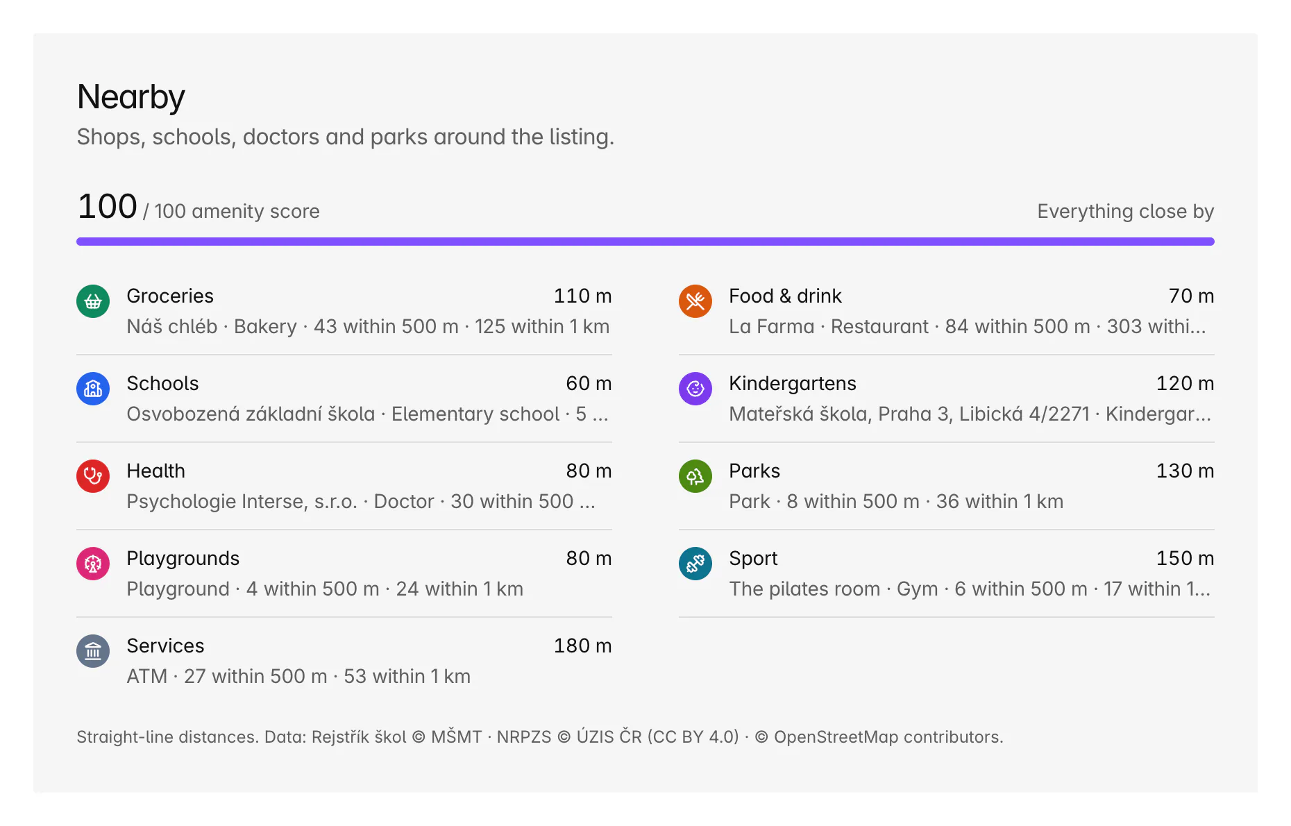
Which places does Bytky count?
Nine kinds of place, the ones that shape a week. For each, the listing shows the nearest by name and distance, and how many lie within 500 m and 1 km.
- Groceries: supermarkets, convenience shops, bakeries, greengrocers, butchers, delis and markets.
- Food and drink: restaurants, cafés, bars, pubs and fast food.
- Schools and kindergartens.
- Health: doctors, dentists, pharmacies and hospitals.
- Parks and playgrounds.
- Sport: gyms, sports centres and pools.
- Services: post offices, banks and cash machines.
Where does the data come from?
From three open datasets, refreshed every week:
- OpenStreetMap, the map anyone can edit: about 91,000 places in Czechia, from bakeries to playgrounds.
- The Ministry of Education's school register (MŠMT): about 15,500 schools and kindergartens.
- The national register of healthcare providers (NRPZS, run by ÚZIS ČR): about 14,700 surgeries, pharmacies and hospitals.
The registers are the authority for schools, kindergartens and health, so a matching OpenStreetMap entry within 75 m is hidden rather than counted twice. Where a register names a doctor in person, Bytky shows the kind of practice instead. The counts are from the import on 12 October 2026.
How is the amenity score worked out?
For each kind of place, 60% of the points come from how close the nearest one is and 40% from how many lie within 1 km. Closeness earns full points within a short walk, 150 m for a grocery shop or a park, and falls to nothing at 1 km. Numbers earn full points at an everyday level, such as 12 grocery shops or 8 parks within 1 km. The kinds are weighted by how much they shape daily life:
- Groceries 20.
- Health and parks 15 each.
- Food and drink, schools, kindergartens and services 10 each.
- Playgrounds and sport 5 each.
The weights were set on Prague's listings so the score spreads out instead of everyone scoring 100: in Prague the median is 94 and one listing in ten scores 62 or less. Across Czechia the median is 52, because rural listings have few places within 1 km.
How do I use it on the map?
Three ways in the explorer, and one on area pages:
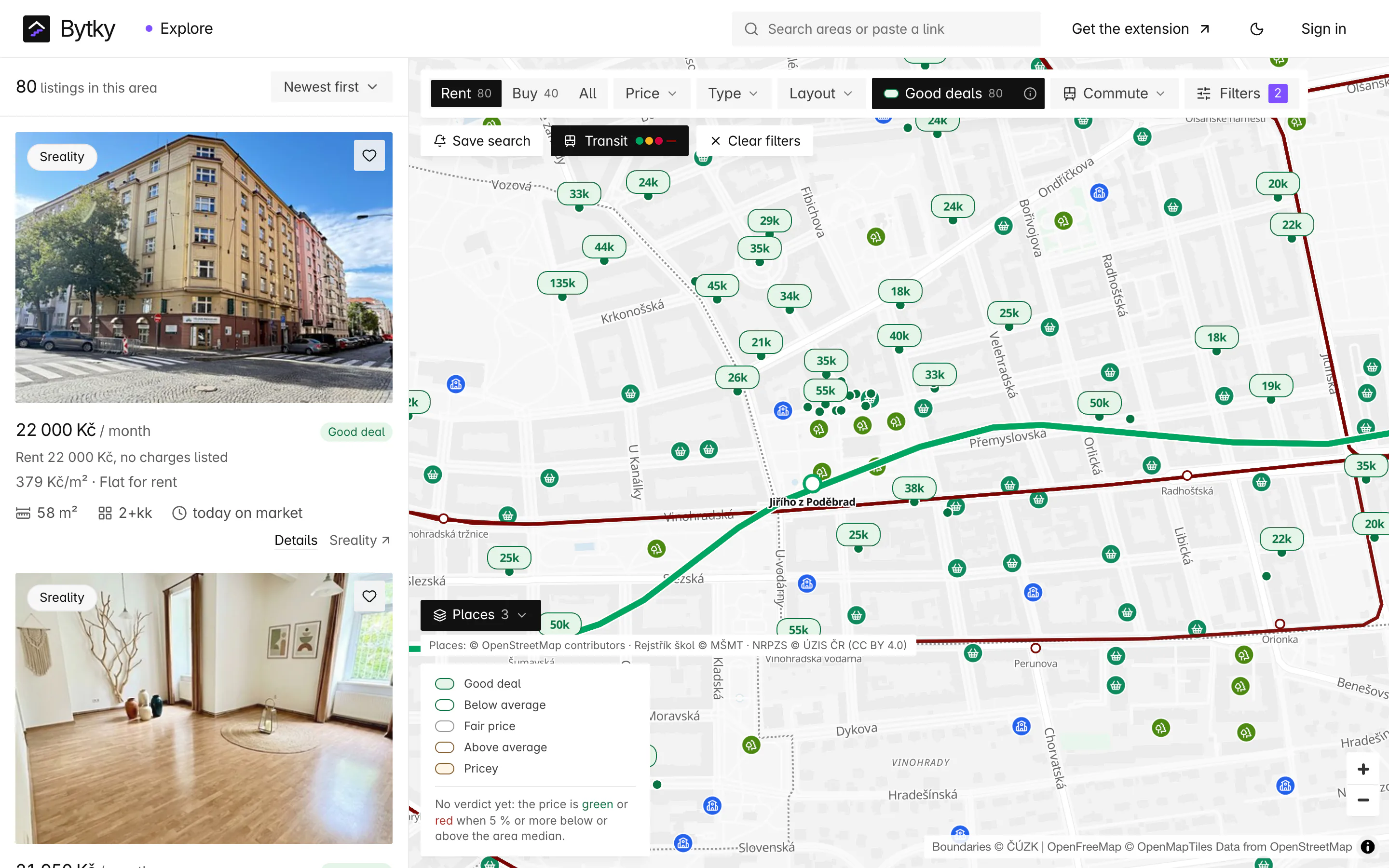
- The Places layer draws the kinds of place you pick, and never covers the listing pins.
- A minimum amenity score keeps only flats at or above it.
- ‘Near a park’ keeps flats with the edge of a park within 500 m.
- Area pages sort their listings by amenity score.
What's nearby in a whole area?
Every area page has an Amenities section: how many places of each kind the area holds, the names worth knowing, and how it compares with the wider area around it. You can see whether a district is well served for schools, or short of doctors, before you look at a single flat.
Coverage and limits
Where does it work, and where does it stop?
Nearby covers the whole of Czechia.
- Distances are straight lines, not walking routes: to the edge of a park, and to the pin of a shop or a school.
- Open data can lag: a new shop may be missing, or a closed café still listed.
- A listing located only to its neighbourhood or town is measured from that point, and the section says it's approximate. The amenity filters only match listings located to their street or better.
- The score measures what's close and how much of it there is, not whether it's any good.
- Places are refreshed weekly.
Map data and places: © OpenStreetMap contributors (ODbL) · Schools: Rejstřík škol © MŠMT · Health providers: NRPZS © ÚZIS ČR, CC BY 4.0
FAQ
Frequent questions
More about Bytky as a whole, from what it costs to where the data comes from.
Read the main FAQWhat is a good amenity score?
It depends where you look. In Prague the median listing scores 94, and one in ten scores 62 or less. Across Czechia the median is 52, because village listings have few places within 1 km. A score of 100 means every kind of place is a short walk away, and plenty of each.
Are the distances walking distances?
No, they're straight-line distances, measured to the edge of a park and to the point of a shop or a school. The walk is usually a little longer, more so across a river or a railway.
Where do the school and doctor lists come from?
From the national registers: schools and kindergartens from the Ministry of Education's register (MŠMT), and surgeries, pharmacies and hospitals from the national register of healthcare providers (NRPZS). Shops, parks, cafés and the rest come from OpenStreetMap.
Can I find flats near a park?
Yes. The ‘Near a park’ filter keeps flats with a park's edge within 500 m, and the Places layer shows the parks themselves on the map.
How up to date are the places?
All three sources are imported every week, and places that disappear from them are removed.
Related features
Where to go next
Know what a flat is worth before you call.
Free for flat hunters. No install and no account to start.